12-31-25
My
longest standing tradition is a hike on Tiger Mountain on New Year's
Eve. My first year of regular hiking was 1982 when I hiked 92 miles. In
1983 I broke 100 miles with 113, ending the year on Tiger Mountain. The
next two years I stopped hiking in the fall and did a last hike on
Tiger to go over 100 miles. In the years since 1983 I have hiked Tiger
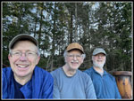
all by one time at end the year. This would be my 42nd time in 43
years. Gary and John signed on. My knee had been sore for a month but
we picked a route of mostly smooth trail with lots of gain and loss.
Gary drove us and we met John at High Point East at 7:40 am. Gary drove
us to the nearby Sunset Way Trailhead. It was 32F at HPE and 34F at
Sunset. We were packed and on our way at 7:55 am. On the drive from
Seattle it was overcast with fog/low clouds except where we rose above
it in Eastgate. I had hope that we would get above the muck for most of
our hike.
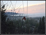
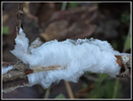
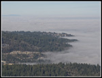
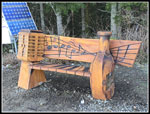
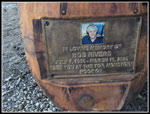
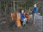
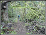
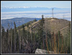
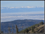
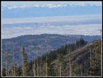
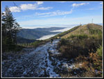
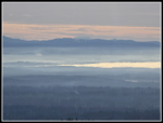
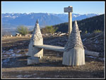
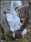
We ascended to the Tradition Plateau and tool the Adventure Trail. A drop to the High School Trail added to our elevation gain for the day. We had to regain that elevation. Along here we saw the first hair ice of the year. It only occurs at temperatures a little below freezing. It is always a treat to see. We took the Poo Poo Point Trail next. The day before, I read that a beautiful carved bench was placed at Poo Poo Point as a memorial for Seattle DJ Bob Rivers. He loved to hike. We added a stop there to check it out. We had lots of solitude on the trail. We arrived at Poo Poo Pt. at 9:44 am. A family was sitting on the bench so we waited for them to leave. The sky was mostly blue but below us was that thick fog. It circled Squak Mountain across from us. The tips of a few distant skyscrapers were just sticking above the fog. It was markedly warmer than at the start below. Issaquah High School was in the clear but everything to the north was under the fog. When the family left we had our change to take photos and sit on the bench. It is a nice addition to the carved benches on Tigers 1, 2, and 3. So far we had covered 3.8 miles.
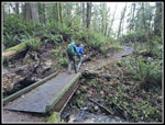
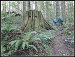
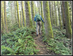
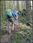
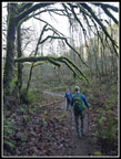
We headed on at 9:57 am. We retraced our steps back to the junction and headed uphill on the One View Trail. We climbed up to the railroad grade and above. The One View has a series of bumps to go over as the ridge ascends. None of us had been up the One View Trail since the Bomb Cyclone wind storm last November. There were trees ripped out of the ground with root ball holes and downed trees. We had to climb over or around a few that looked more recent. Overall, the trail is in good shape. We took a short break when we reached the Tiger Mountain Trail (TMT). A short hike to the right we reached the Hidden Valley Trail. That begins at a very steep grade. My knee feels a steep descent more that ascent and I was fine. This section ends at a main road and the start of the Poo Top Trail. The Poo Top is also very steep in places as it rises to the top of Tiger 1 at 2950'. Our starting elevation was about 125', We hiked slowly and steadily up the ridge.The trail pops out of the forest into a clearcut at a junction right below the summit. We chose to turn right and proceed to the summit.
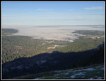
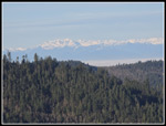
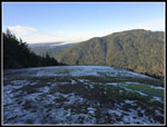
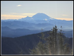
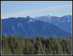
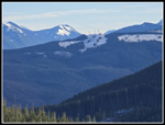
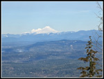
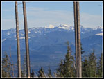
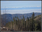
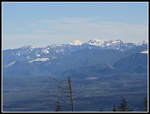
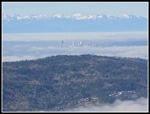
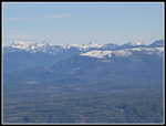
From the top we had great views all around. Below was mostly in fog but we had blue sky and lots of sunshine. Mt. Rainier was to the south. West Rattlesnake at 3250' had lots of snow at the clearcut summit. We were just a little lower but had almost no snow. Five days earlier Gary and I had full snow cover at 2757' Tiger 2. Today, snow only existed in small shaded areas. To the north Mt. Baker and Three Fingers were very white with fresh snow. Glacier Peak could be seen along with Mt. Si and summits up towards Snoqualmie Pass. Blue sky and views or snowy peaks are not a usual occurrence at the end of December. We each have a thermometer on our packs and they were all snowing 55 or 56 degrees. An inversion had it sub-freezing at ground level but balmy nearly 3000' up. It almost felt like spring. We had lunch below the summit. We then headed back to the junction and continued to the west side of Tiger 1. There was a group at the Hikers Hut. Mt. Rainier was now much hazier than when we first saw it. Seattle skyscrapers were partly out of the fog. The Olympic Mountains were in sight all day long.
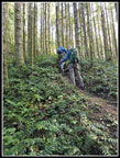
We only stopped for some photos and began the steep descent and then climb to the top of Tiger 2. I knew that the steep rocky road would be the hardest section in my knee. It was. I went slowly and with poles I made it down okay. I was really sweating on the climb to Tiger 2 at it felt all of a sunny 55F. On top it was warm with little breeze. I could have spent an hour there. Gary was more keen on a shorter stop. We arrived on top at 12:39 pm. We started down at 12:51 pm. It sure was nice in the sunshine. Once we dropped off the north side of Tiger 2 we would be in shady forest for the rest of the hike. So far we had covered 7.6 miles with about 3400' of gain. One feature of our route is that we gained 400' more than we lost. HPE is higher than Sunset Way.
There was some ice on the trail from packed down snow freezing and thawing. Once we dropped below the clearcut the trail was bare in forest. We saw other hikers at Poo Poo Point and at the two summits buts saw very few elsewhere. I don't recall seeing anyone on the hike down from Tiger 2. The TMT is mostly a smoothly graded trail that did not stress my knee much. There are a few big steps near the top. We just hiked along at a moderate pace as we would be done well before sunset. As we descended to the last mile it became much colder. It was now late afternoon and should have been the heat of the day. I put gloves back on. We had one last dirt road that sits below a powerline corridor. Trucks very occasionally use it for maintenance trips. Years ago, a truck was stuck in axle deep mud repairing a broken power pole. They laid hundreds of rocks on the road to make it passable. Fast forward to 2025. They laid a ton of dirt on the road. After fall and winter rain, it is a quagmire. It is now even worse than before the rocks were placed. Not a good idea. We passed through without submerging our boots.
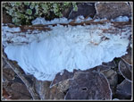
The trail ends at a gated paved road at a low spot before climbing up to where we parked. It was winter here. There was ice that never melted all day. Gary pointed out big patches of hair ice. It was never over freezing all day long. I could not believe it was this cold. 2400' higher on Tiger 1 it was 55F in late morning. Back at the car it was a bit warmer at 34F. I'm bit amazed that I have managed to get out on Tiger in all weather on NYE for 42 of 43 years. As I said earlier, it is my longest standing tradition. We had great weather this year and a memorable 11 mile one way hike with 3600' of elevation gain. I hope to have many more year end hikes on Tiger Mountain.
Click on thumbnails to get
larger pictures.
Trips - 2025
Home
We ascended to the Tradition Plateau and tool the Adventure Trail. A drop to the High School Trail added to our elevation gain for the day. We had to regain that elevation. Along here we saw the first hair ice of the year. It only occurs at temperatures a little below freezing. It is always a treat to see. We took the Poo Poo Point Trail next. The day before, I read that a beautiful carved bench was placed at Poo Poo Point as a memorial for Seattle DJ Bob Rivers. He loved to hike. We added a stop there to check it out. We had lots of solitude on the trail. We arrived at Poo Poo Pt. at 9:44 am. A family was sitting on the bench so we waited for them to leave. The sky was mostly blue but below us was that thick fog. It circled Squak Mountain across from us. The tips of a few distant skyscrapers were just sticking above the fog. It was markedly warmer than at the start below. Issaquah High School was in the clear but everything to the north was under the fog. When the family left we had our change to take photos and sit on the bench. It is a nice addition to the carved benches on Tigers 1, 2, and 3. So far we had covered 3.8 miles.
We headed on at 9:57 am. We retraced our steps back to the junction and headed uphill on the One View Trail. We climbed up to the railroad grade and above. The One View has a series of bumps to go over as the ridge ascends. None of us had been up the One View Trail since the Bomb Cyclone wind storm last November. There were trees ripped out of the ground with root ball holes and downed trees. We had to climb over or around a few that looked more recent. Overall, the trail is in good shape. We took a short break when we reached the Tiger Mountain Trail (TMT). A short hike to the right we reached the Hidden Valley Trail. That begins at a very steep grade. My knee feels a steep descent more that ascent and I was fine. This section ends at a main road and the start of the Poo Top Trail. The Poo Top is also very steep in places as it rises to the top of Tiger 1 at 2950'. Our starting elevation was about 125', We hiked slowly and steadily up the ridge.The trail pops out of the forest into a clearcut at a junction right below the summit. We chose to turn right and proceed to the summit.
From the top we had great views all around. Below was mostly in fog but we had blue sky and lots of sunshine. Mt. Rainier was to the south. West Rattlesnake at 3250' had lots of snow at the clearcut summit. We were just a little lower but had almost no snow. Five days earlier Gary and I had full snow cover at 2757' Tiger 2. Today, snow only existed in small shaded areas. To the north Mt. Baker and Three Fingers were very white with fresh snow. Glacier Peak could be seen along with Mt. Si and summits up towards Snoqualmie Pass. Blue sky and views or snowy peaks are not a usual occurrence at the end of December. We each have a thermometer on our packs and they were all snowing 55 or 56 degrees. An inversion had it sub-freezing at ground level but balmy nearly 3000' up. It almost felt like spring. We had lunch below the summit. We then headed back to the junction and continued to the west side of Tiger 1. There was a group at the Hikers Hut. Mt. Rainier was now much hazier than when we first saw it. Seattle skyscrapers were partly out of the fog. The Olympic Mountains were in sight all day long.
We only stopped for some photos and began the steep descent and then climb to the top of Tiger 2. I knew that the steep rocky road would be the hardest section in my knee. It was. I went slowly and with poles I made it down okay. I was really sweating on the climb to Tiger 2 at it felt all of a sunny 55F. On top it was warm with little breeze. I could have spent an hour there. Gary was more keen on a shorter stop. We arrived on top at 12:39 pm. We started down at 12:51 pm. It sure was nice in the sunshine. Once we dropped off the north side of Tiger 2 we would be in shady forest for the rest of the hike. So far we had covered 7.6 miles with about 3400' of gain. One feature of our route is that we gained 400' more than we lost. HPE is higher than Sunset Way.
There was some ice on the trail from packed down snow freezing and thawing. Once we dropped below the clearcut the trail was bare in forest. We saw other hikers at Poo Poo Point and at the two summits buts saw very few elsewhere. I don't recall seeing anyone on the hike down from Tiger 2. The TMT is mostly a smoothly graded trail that did not stress my knee much. There are a few big steps near the top. We just hiked along at a moderate pace as we would be done well before sunset. As we descended to the last mile it became much colder. It was now late afternoon and should have been the heat of the day. I put gloves back on. We had one last dirt road that sits below a powerline corridor. Trucks very occasionally use it for maintenance trips. Years ago, a truck was stuck in axle deep mud repairing a broken power pole. They laid hundreds of rocks on the road to make it passable. Fast forward to 2025. They laid a ton of dirt on the road. After fall and winter rain, it is a quagmire. It is now even worse than before the rocks were placed. Not a good idea. We passed through without submerging our boots.
The trail ends at a gated paved road at a low spot before climbing up to where we parked. It was winter here. There was ice that never melted all day. Gary pointed out big patches of hair ice. It was never over freezing all day long. I could not believe it was this cold. 2400' higher on Tiger 1 it was 55F in late morning. Back at the car it was a bit warmer at 34F. I'm bit amazed that I have managed to get out on Tiger in all weather on NYE for 42 of 43 years. As I said earlier, it is my longest standing tradition. We had great weather this year and a memorable 11 mile one way hike with 3600' of elevation gain. I hope to have many more year end hikes on Tiger Mountain.
 Fog From Plateau |
 Hair Ice |
 Poo Poo Point Trail |
 Poo Poo Pt. View |
 Fog Below Squak Mt. |
 Olympic Mountains |
 Bob Rivers Bench |
 Bob Rivers Plaque |
 Gary & John At Bench |
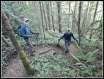
 Three Amigos |
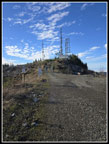
 Frozen Take Off Zone |
 Stump Eyes |
 Mossy Arch |
 Ascending |
 Poo Top Trail |
 Steep Spot |
 Mt. Rainier |
 View East |
 West Rattlesnake Mt. |
 Mt. Baker |
 Framed Glacier Peak |
 Near Tiger 1 Summit |
 Olympics Again |
 Glacier Peak Closer |
 Tiger 2 |
 Seattle In Sight |
 Seattle Closer |
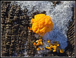
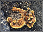 Colorful Fungus |
 Heading Down |
 Seattle & Olympics |
 Wild Sky Peaks |
 Mt. St. Helens |
 Tiger 2 Bench |
 Witches' Butter |
 The Wiggle |
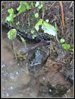 Giant Pacific Salamander |
 Christmas Tree |
 Mossy Branches |
 Hair Ice Again |
 Final Hair Ice |
Trips - 2025
Home